Skip to content

Our Flagship

The Hercules Project

A highly prospective silver asset with over 28,000 meters of drilling in over 300 historical drill holes, across 3.5 kilometers of strike. Shallow mineralization open in all directions, with the best surface targets still to be tested.

Hercules Project

Overview

Hercules is a replacement-style disseminated silver (lead-zinc-manganese+/-copper) system hosted in a Jurassic aged volcanic tuff of rhyolitic composition (the “Hercules Rhyolite”). 

Modern systematic exploration by the Company has located a porphyry copper target in the adjacent andesitic volcanic rocks underlying the Hercules Rhyolite to the east. Shallow level porphyry style alteration has been mapped within a new copper-in-soil anomaly extending over 2 kilometers from the historically defined silver mineralization.

The disseminated silver-lead-zinc mineralization has been de-risked by over 28,000 meters of drilling across 3.5 kilometres of strike. Historical operators were focused on developing a shallow high-grade open pit resource with short vertical drill holes, preventing a full understanding of structural controls.  The Company has aggressive plans to drill over 5.5 kilometers of strike, verify the historical drilling and its suitability towards a maiden resource estimate, as well as test the new 2 kilometer long copper porphyry target discovered in 2021/2022.

LAND

The Hercules property is located mostly on Idaho state land with grandfathered exploration, mining and milling rights. Idaho is ranked one of the top jurisdictions in the world for mining regulations, taxation regime and permitting policy.

Location

4,246 acres located in Washington County, Idaho, just 2.5 hours northwest of Boise International Airport by highway.

Fraser Institute, 2021

Idaho was ranked 7th in the world for investment attractiveness, based on geological potential, favorable mining regulation, taxation and political support.

Last Mined
1882
Last Explored
1920
Acquired
1980

Highlights

Location

4,246 acres located in Washington County, Idaho, just 2.5 hours NW of Boise International Airport by Highway. High voltage transmission line traverses across the property.

Geology

Replacement-style oxide and sulfide silver (lead-zinc-manganese+/-copper) as breccias and fracture-fillings hosted within a Jurassic rhyolite tuff, which is underlain by interbedded andesitic volcanics and carbonates which display porphyry-style alteration accompanied by strong copper-in-soil values at surface.

Deposit Type

Analogous to the Hardshell deposit in Arizona, a high-grade silver-lead-zinc-manganese deposit associated with the Hermosa-Taylor carbonate replacement deposit (CRD). Porphyry-style mineralization/alteration occurs to the east, in stratigraphically deeper volcanics and carbonates at Hercules.

Near Term Development Optionality

Robust standalone development project that could be potentially integrated with nearby mines.

Drilling

28,000 meters of drilling have been completed in over 300 historical drill holes, spanning 3.5 kilometers of strike. Two zones of continuous mineralization at shallow depth, which remain open in all directions. Phase II 6,000 m drill campaign currently underway.

Exploration

2022 soil sampling and historical IP surveys indicated the best targets remain to be tested, with over 5.5 kilometers of anomalous soils and a new untested porphyry-style copper anomaly immediately adjacent to the east of the CRD-style silver mineralization, these targets are a priority in 2023 exploration.

Current

Exploration

The November 2022 Phase I drill program was designed to test and verify historical drilling assays as well as gain the geological and geotechnical information needed to support a Phase II drilling campaign in early spring of 2023. 

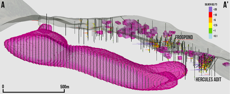
The program consisted of infill and step-out holes at the Frogpond and Hercules Adit Zones with additional step-out holes to test open zones with little to no prior drilling. 

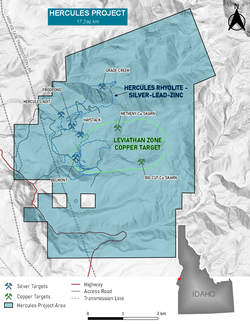
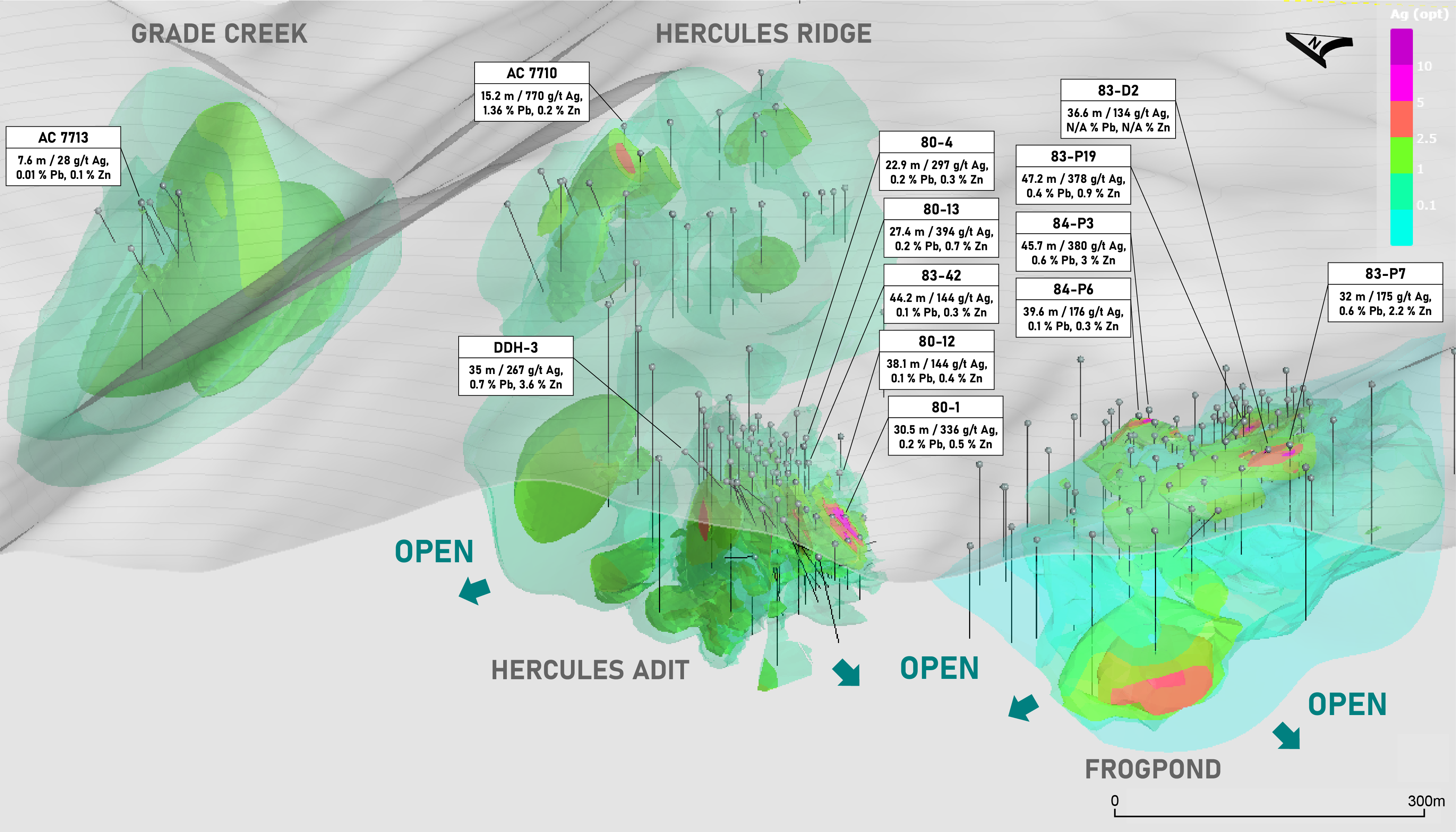
A total of 1,995 feet in 9 drill holes was completed, with several holes bottoming in mineralization, and high-priority areas were tested within the Frogpond and Hercules Adit Zones for potential inclusion in future resource estimates. (See Feb 28 NR).

Highlights of the program include: 

  • Strong grade over multiple significant intervals, including drill hole HER-22-01, the first hole of the program, which intercepted 38 meters of 353 g/t Ag, 0.64% Pb, 2.28% Zn and 0.16% Cu (487 g/t AgEq), beginning at a shallow depth of 26 m depth in first drill hole, HER-22-01.
  • HER-22-01 included a higher-grade intercept of 4.57 m grading 791 g/t Ag, 1.25% Pb, 4.06% Zn and 0.18% Cu (1,021 g/t AgEq) starting at 29 m.
  • HER-22-07 intersected 44.2 m grading 224 g/t Ag, 0.32% Pb, 0.38% Zn and 0.09% Cu (258 g/t AgEq) starting at 1.5 m.
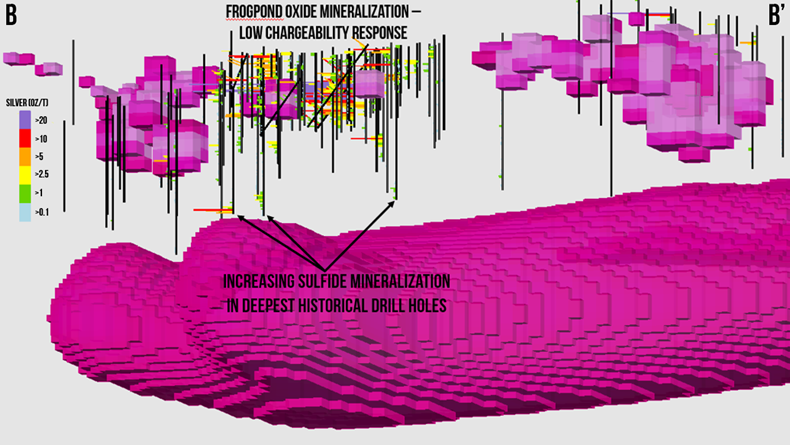
  • Drilling grades significantly exceed grades sampled at surface, supporting the concept of potential supergene enrichment of mineralization below surface.
  • Confirmed the presence of a high-grade shoot (the P-19 Shoot) at the east end of the Frogpond Zone; open at depth to the east.
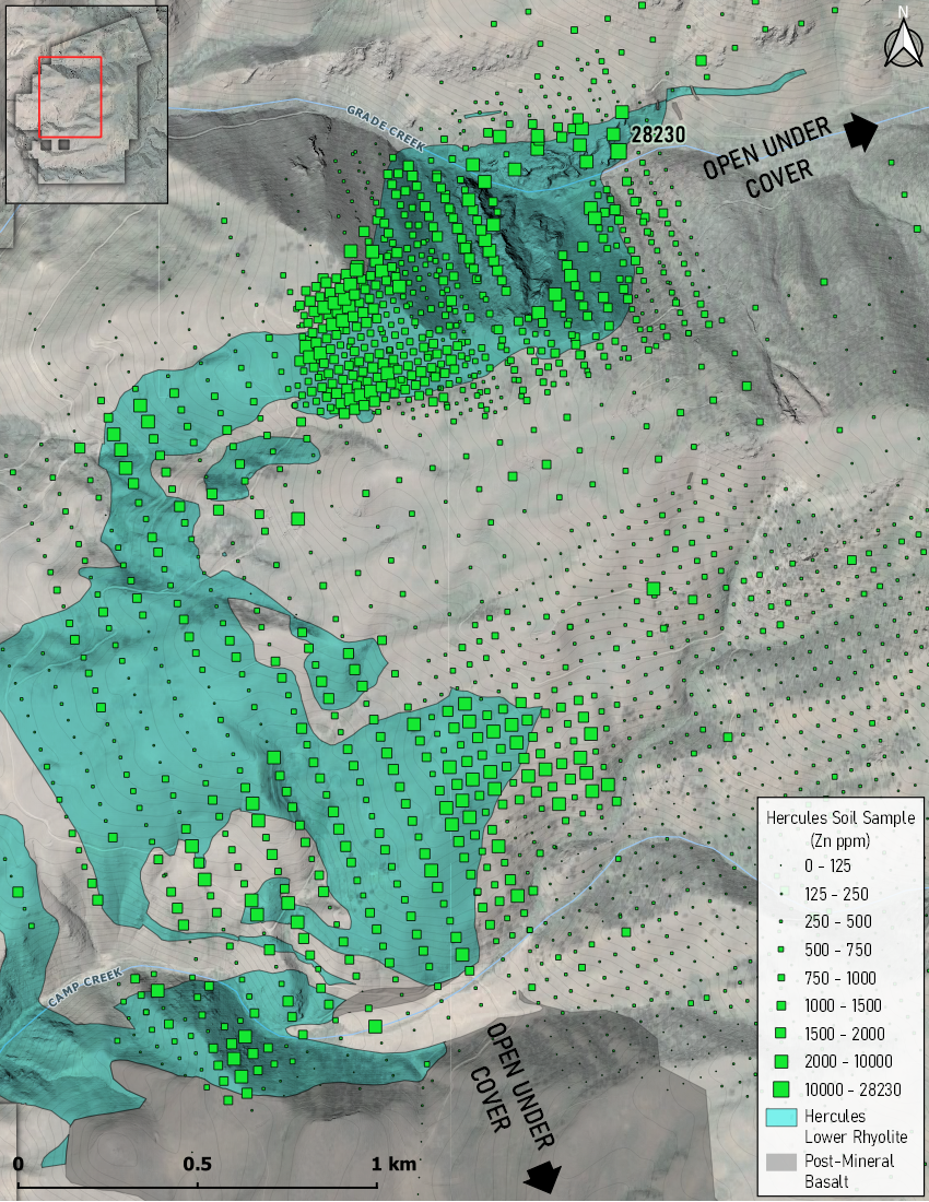
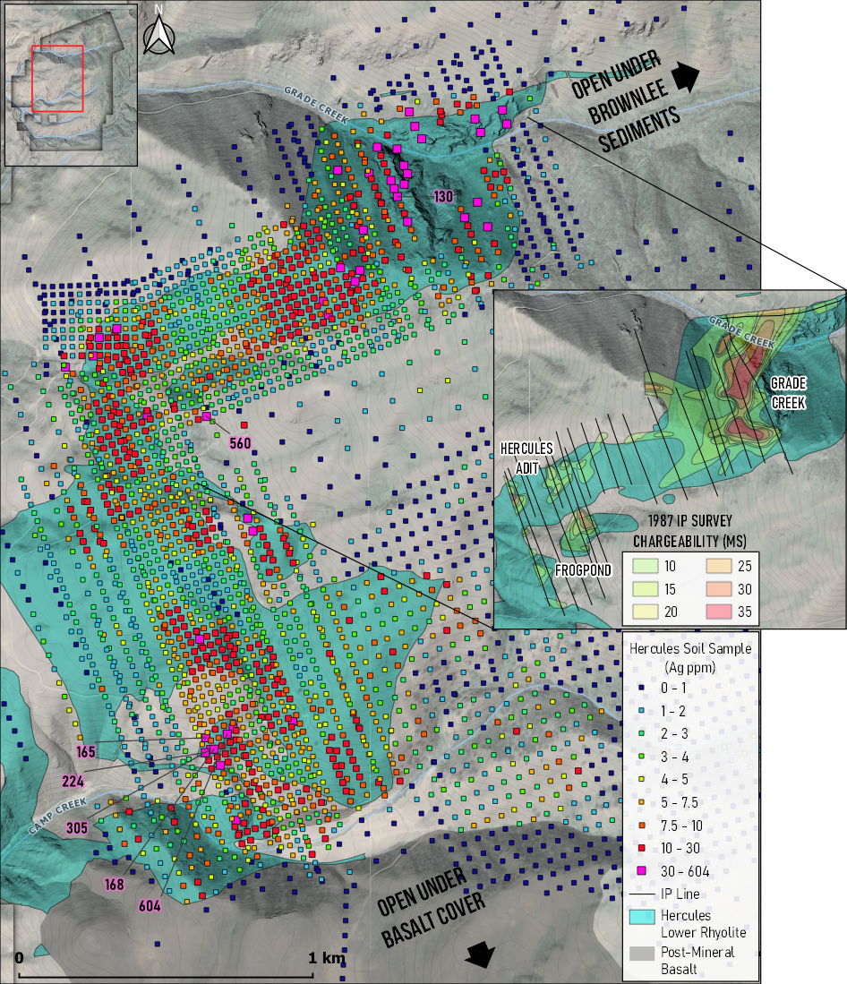
  • Confirmed the presence of shallow, high-grade mineralization at Frogpond and Hercules Adit Zones, with additional follow-up planned for Phase II.

The new 3D IP survey over the Hercules Adit, Frogpond and Belmont Zones, identified a large untested chargeability anomaly at depth. The results demonstrate the excellent exploration potential at Hercules and will contribute to 2023 drilling.

  • Strong chargeability values (>25ms), below historical drilling, and over a continuous strike length of 1.8 kilometers
  • Anomaly is coincident with the untested base of the Hercules Rhyolite where surface mapping indicates the strongest silver mineralization to occur (See Oct 18 NR)
  • Lower portion of anomaly lies down dip of the copper mineralization hosted within the underlying Seven Devils volcanics
  • Anomaly remains open up-dip to the southeast

3D video of the new anomaly

The summer 2023 Phase II drill program will consist of step-out holes designed to test for extensions of historical mineralization, verify previous historical drilling and test a series of new targets generated by greenfields exploration.

The 6,000 m program is focused on the following targets:

  • Hercules Adit and Frogpond Zones: Step-out holes aiming to extend mineralization, as well as infill and further verify historical drilling results;
  • Hercules Rhyolite: Robust silver targets identified through surface mapping, geophysics and geochemistry, including at the Hinge, Haystack and Belmont Zones;
  • New porphyry copper-silver (+/- gold) target: Interpreted as the center of a large zoned system and feeder for the surrounding silver (+/-lead-zinc) hosted in the Hercules Rhyolite;
  • Large-scale untested chargeability anomaly at depth, potentially representing a large body of strong sulfide mineralization
Phase II Drill Targets

Technical

Maps & Figures

Historical

Drilling

Paper drill logs from the 1960’s-1980’s were recovered and digitized into a modern database.  Assays include:

Hole ID

Year

From (m)

To (m)

Interval (m)

Ag (g/t)

Pb (%)

Zn (%)

80-1198073.15103.6330.48335.60.170.54
including198082.391.449.14828.20.240.8
including198096.0199.063.05317.80.040.22
80-1219807.6222.8615.2456No AssayNo Assay
AND198036.5874.6838.1144.30.130.37
including198050.2953.343.05485No AssayNo Assay
AND198082.397.5415.241290.020.07
80-131980114.3141.7327.43394.30.210.7
including1980115.82126.4910.67904.30.321.31
80-04198085.34108.222.86297.40.220.26
83-4219831.5245.7244.2143.90.130.26
including198312.1915.243.05807.70.250.21
83-P19198315.2462.4847.24377.50.390.91
Including198324.38327.62606.20.491.64
Including198335.0544.29.151,166.401.051.82
83-P7198342.6774.6832.01174.60.562.21
84-P3198425.9171.6345.72380.30.613
Including198427.4333.536.1998.91.187.53
84-P619844.5744.239.63175.90.120.32
AC 7710197744.259.4415.247701.360.2
Including197748.7756.397.621,377.702.620.3
AND1977126.49132.596.1146.20.050.1
DDH-3196533.5335.051.52289.30.1No Assay
AND196544.268.5824.38122.9No AssayNo Assay
AND196582.3117.3535.05266.70.693.63
Including196592.9699.066.1718.50.481.63
RC 771197777.72109.7332.01300.30.220.49
including197797.54106.689.14750.10.340.4

Above:  Select historical intercepts from 1965-1988 demonstrate some of the better holes drilled

Historical

Timeline

1880
First production at the Belmont Zone
1965
First hole drilled at the Hercules Adit Zone which was mined in the early 1900’s for high-grade silver
1983 -1984
144 holes drilled in 1983-84, followed by a collapse in silver prices shortly thereafter, leaving the project orphaned throughout the bear market of the 90’s and early 2000’s ​
2022
New exploration completed, including digitizing the entire historical exploration database; Prepared robust 3D geological model in Leapfrog; Increased property size via direct staking of prospective ground; Collected over 2,500 soil samples , and identified, mapped and prospected a new porphyry copper style anomaly
1920s
Production at the Hercules Adit
Late 1970s - Early 1980s
Strong silver prices lead to aggressive drilling at the Fishpond and Hercules Adit Zones, defining two zones of continuous mineralization. Drilling along strike successfully discovered 4 other zones at the Belmont, Haystack, Hercules Ridge and Grade Creek
2021
Hercules Silver Corp. (formerly Bald Eagle Gold) acquires the Hercules Project
2023
Exploration Plans going forward: Property-wide chip and channel sampling of untested mineralized outcrops; Property-wide 3D IP geophysical survey; Detailed structural, stratigraphic and alteration mapping; Confirmation drilling of select historical drill holes; Metallurgical testing of both oxide and sulfide mineralization; Assess suitability of maiden resource estimate; Step-out drilling on the Hercules Adit and Fishpond Zones; Exploration drilling of new targets identified by Hercules Silver

Subscribe toour newsletter!

Stay on top of Hercules’ progress by signing up for our newsletter.